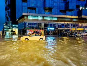
In April 2024, the UAE experienced a record-breaking 254 liters of rain per square meter in 24 hours, highlighting the increasing frequency of extreme weather events due to climate change. This unprecedented downpour caused major disruptions, including the temporary closure of Dubai’s airport, one of the busiest transport hubs globally. However, it wasn’t only the UAE that faced this extreme weather—neighboring countries like Bahrain, Oman, Qatar, and Saudi Arabia also experienced intense rainfall, resulting in fatalities and significant economic losses.
While some might attribute these heavy rains to practices like “cloud seeding,” the underlying issue is the broader impact of climate change. Research from the University of Helsinki highlights that the Middle East is warming at twice the rate of the global average, leading to more frequent and severe weather events, such as storms and flooding. This puts considerable strain on the region’s infrastructure, economies, and communities, especially those that are already vulnerable to such environmental challenges.
The Need for Early Warning Systems in Flood Management
The region’s unique geography—characterized by extended dry spells followed by intense rainfall—makes it highly susceptible to flooding. During the rainy season, from October to April, heavy showers can overwhelm drainage systems in urban areas, leading to flash floods that disrupt daily life, damage infrastructure, and pose serious threats to human safety. To address this challenge, effective early warning systems (EWS) are essential. These systems use advanced technologies to predict and communicate the likelihood of floods, giving authorities the tools they need to prepare and mitigate damage before it happens.
Key Technologies Used in Early Warning Systems
Hydrological Modeling and Predictive Tools:
Early warning systems rely on sophisticated hydrological models that simulate river and reservoir behavior under different weather conditions. These models can predict when and where floods are likely to occur, as well as the scale of the event. By integrating weather data, terrain information, and historical flood patterns, authorities can issue more accurate and timely warnings, which is critical for flood preparedness.
Real-Time Meteorological Data:
Automatic rain gauges and satellite weather monitoring provide real-time data on precipitation levels, helping forecast storm patterns and rainfall intensity. This information is crucial for predicting the timing and severity of floods. When combined with predictive models, it allows for more precise forecasting, enabling quicker decision-making by authorities.
Artificial Intelligence and Big Data:
Artificial intelligence (AI) plays a significant role in early warning systems by processing vast amounts of data, including historical rainfall and flow patterns, to predict future flood risks. AI enhances the accuracy of forecasts and enables the system to recognize patterns that might not be immediately obvious to human analysts. Additionally, big data analytics help simulate various flood scenarios, providing authorities with comprehensive risk assessments and facilitating better preparedness strategies.
Geospatial Information Systems (GIS):
GIS technologies are critical for visualizing flood risks. By mapping vulnerable areas and tracking floodwater in real-time, GIS helps authorities understand the spread of floodwaters, identify at-risk infrastructure, and prioritize emergency response efforts. These systems can also inform long-term urban planning, helping cities design more resilient infrastructure and drainage systems.
The Importance of Environmental Testing in Flood Risk Management
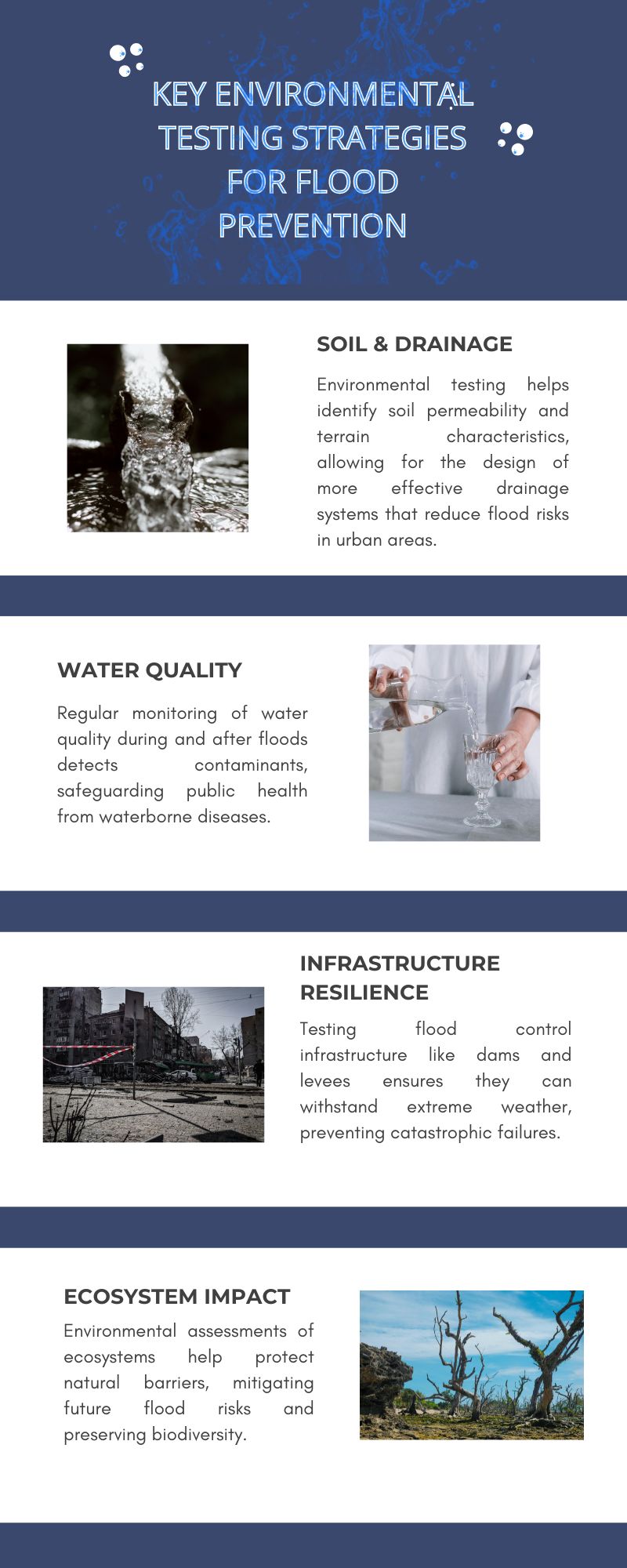
While early warning systems are vital, environmental testing is also essential for assessing and managing flood risks in the region. Regular testing of environmental factors such as soil composition, water quality, and infrastructure resilience provides valuable data for improving flood prevention and response strategies.
Soil and Terrain Testing:
The type of soil and the slope of the land play a significant role in how floodwaters behave. Testing soil permeability helps determine how quickly water will be absorbed or whether it will run off, contributing to flooding. Urban areas, with extensive impermeable surfaces like asphalt and concrete, tend to see more surface runoff, which exacerbates flooding. Environmental tests can help urban planners and engineers design better drainage systems and flood mitigation strategies based on the soil’s characteristics.
Water Quality Monitoring:
Flash floods often result in water contamination, as stormwater picks up pollutants from roads, sewage systems, and industrial areas. Regular water quality testing is crucial to monitor contamination levels after floods, ensuring public health is protected. Tests for pollutants like bacteria, chemicals, and heavy metals are essential for managing waterborne diseases and addressing potential health risks following flooding.
Infrastructure Resilience Testing:
Flood control infrastructure such as dams, levees, and drainage systems must be rigorously tested to ensure they can withstand extreme weather conditions. Environmental testing of these systems helps identify vulnerabilities before disasters strike, enabling engineers to reinforce or repair infrastructure to prevent failures during floods.
Ecosystem Impact Assessments:
Flooding can have severe consequences on local ecosystems, affecting everything from agriculture to wildlife. Environmental testing helps authorities assess the ecological impact of floods, especially in sensitive areas like wetlands and coastal zones. Understanding how flooding affects biodiversity and ecosystems is essential for sustainable flood management and for protecting natural barriers that help mitigate future flood risks.
Combining Early Warning Systems and Environmental Testing for Greater Impact
When combined with real-time data from early warning systems, environmental testing enhances the accuracy and effectiveness of flood management efforts. For example, testing the resilience of flood control infrastructure and understanding the local terrain can inform how authorities should respond to flooding events predicted by early warning systems. Similarly, environmental testing of water quality can guide public health responses during and after flood events.
The integration of environmental data into early warning systems makes these systems more robust and better suited to dealing with the complexities of flood management in a rapidly changing climate. Real-time alerts are invaluable for enabling timely decision-making and preparing local authorities, utilities, and emergency agencies to take proactive measures. When these systems are supported by environmental data and analysis, the response to floods becomes even more effective, ultimately saving lives and reducing damage.
A Collaborative and Comprehensive Approach to Climate Resilience
To build long-term resilience against extreme weather events like floods, a collaborative and integrated approach is necessary. Early warning systems should be linked with other climate adaptation measures, including Digital Twins, climate models, and sustainable urban planning. Digital Twins, for instance, can create virtual replicas of infrastructure and flood-prone areas, enabling authorities to test various flood scenarios and responses in real time.
By combining climate predictions, real-time data, and environmental testing with predictive modeling, cities can enhance their flood resilience and create more sustainable infrastructure. These strategies can also integrate green infrastructure such as rain gardens and permeable pavements, which help manage stormwater more naturally and reduce the risk of flooding.
Building a Sustainable Future Through Innovation
To effectively manage the growing flood risks, the Middle East needs to embrace climate-smart urban planning and invest in sustainable infrastructure. This includes designing drainage systems that can handle increased water volumes, using materials that allow better absorption of rainwater, and implementing flood-control solutions that incorporate nature-based approaches.
In addition, investments in smart water management and renewable energy can further enhance resilience. For instance, smart irrigation systems can optimize water use, while energy-efficient infrastructure can reduce the environmental impact of flood management efforts.
Conclusion
As different countries face more frequent and intense extreme weather events, it is essential for governments, utilities, and urban planners to prioritize investments in technologies like early warning systems, artificial intelligence, and GIS. However, these innovations must be complemented by regular environmental testing, climate adaptation measures, and sustainable infrastructure. By integrating technological tools with sound environmental data and long-term planning, the region can build resilience against floods and other climate-related disasters, safeguarding both communities and economies for the future.
Leave a Reply